Archive for the 'Survey Extension' Category

Surface Creation Tools – 2010 Version

For those users that used the survey extension in AutoCAD MAP3D 2009 and were using the Surface Creation tool you might of been a little disappointed with 2010 version lack of that tool. The rest of the survey tools were incorporated into the Survey Tab on the map task pane but the surface tool was left out.

Well not to worry Autodesk heard us complaining and did something about it. Actually back in the beta stages the complains and question about the surface tool where first brought up to the Map3D team. Although it was too late to get in the release versions Autodesk Map3D team has the solution.

Up on your subscription site under the product download section there is the 2010 version of the Surface Creation Extension, both a 32bit and a 64 bit version. Download and install and you will have the same tool that was in the 2009 version with one little missing function. The missing function is the export the points to drawing points, which you can now use the (map) import tools to accomplish that.

If you had not used the 2009 version Survey Extension or the Surface Creation tool you may want to take a look at my post here to get an idea of what it can do.  That’s only one of the task you can use it for, the main function of it was to allow users to import a topo survey in ASCII format and create a Geo-TIFF raster file.

SP1 and Hotfix for Survey Extension

For those running Map3D 2009 I’m sure you know a service pack has been out for a while. For those that do not know it, it fixed a few bugs but it also caused the Survey Extension to have a few issues when you created a TIN surface. You had to close AutoCAD Map3D, reopen Map3D, and manually load/connect to the raster TIN surface to see the surface. Well the hot fix for it is out and on the Autodesk web site. The SP1 is also downloadable from there if you have not installed it yet. Those that have not downloaded the Survey Extension yet the hot fix should not be required. Like any Update or SP make sure you read the readme files before you install the SP or hotfix.

Create a 3D Surface from a SHP File. (with survey extension)

Do you have the need to create a surface from a ESRI contour file, and that shape file is just 2D with the elevation as an attribute? The new released Survey Extension For Map3D will do it. It is as easy as 1, 2, 3.

Step 1. Use the data connect to connect to the shape file.

Connect_Shape

Note: all you need is to connect to it there is no need to add it to the map.

Step 2. Use the “Mapcreatesurface” command to open the Create Surface dialog.

Create_Icon

The Create surface tool is on the Input and Inquiry toolbar. if not just type the command at the command line.

Select_Connection

In the Create Surface Dialog, select “Connection” for the source and select the shp connection you made in the data connect.

Set_Z

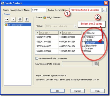
Step 3. Provide a name and location for the Raster TIFF that will be created. Then select the field that contains the Elevation value in the attribute table.

Now press the OK button.

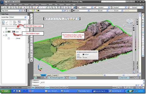
Now the results after setting a style to the surface feature layer and placing the original contours above it in the draw order.

Finished

OK if you count all the mouse clicks it may be more than 3 steps but, its quicker than firing up ArcInfo and using the tools to create the surface there then  connect to it.

To those that may want to question the accurately of this compared to ESRI software, well I took the same shp file in ArcMAP created a TIN from it and converted that into a Raster.  I then added that to this dwg and compared them in both 2D and 3D views. To me I didn’t see any difference between the two.


Archives

Readers Locations

Top Rated posts

Chat room